一、安装postgres_postgis_pgrouting
version: '3'
services:
  postgres:
    image: starefossen/pgrouting
    container_name: postgres_postgis_pgrouting
    restart: always
    privileged: true
    volumes:
      - ./pgdata:/var/lib/postgresql
    environment:
      TZ: Asia/Shanghai
      POSTGRES_USER: postgres #在此填写postgres的用户名
      POSTGRES_DB: postgres #在此填写postgres的数据库名,默认是postgres
      POSTGRES_PASSWORD: postgres #在此填写posgres的数据库密码
    ports:
      - "5432:5432"
    logging:
      options:
        max-size: 10mb
二、创建扩展:
pgrouting要依赖postgis。
新建数据库后,运行:
CREATE EXTENSION PostGIS
CREATE EXTENSION pgRouting
三、样例数据:
pgrouting官网提供了一个很简单的样例数据,讲拓扑路网数据如何构建:
https://docs.pgrouting.org/3.0/en/sampledata.html
创建表
# edge_table
# 新建数据表edge_table,这张表存储所有道路线信息,查询大部分都是基于这张表:
CREATE TABLE edge_table (
    id BIGSERIAL,
    dir character varying,
    source BIGINT,
    target BIGINT,
    cost FLOAT,
    reverse_cost FLOAT,
    capacity BIGINT,
    reverse_capacity BIGINT,
    category_id INTEGER,
    reverse_category_id INTEGER,
    x1 FLOAT,
    y1 FLOAT,
    x2 FLOAT,
    y2 FLOAT,
    the_geom geometry
);
插入数据,都是两点线段(添加原数据17-18段路网不通):
INSERT INTO edge_table (
    category_id, reverse_category_id,
    cost, reverse_cost,
    capacity, reverse_capacity,
    x1, y1,
    x2, y2) VALUES
(3, 1,    1,  1,  80, 130,   2,   0,    2, 1),
(3, 2,   -1,  1,  -1, 100,   2,   1,    3, 1),
(2, 1,   -1,  1,  -1, 130,   3,   1,    4, 1),
(2, 4,    1,  1, 100,  50,   2,   1,    2, 2),
(1, 4,    1, -1, 130,  -1,   3,   1,    3, 2),
(4, 2,    1,  1,  50, 100,   0,   2,    1, 2),
(4, 1,    1,  1,  50, 130,   1,   2,    2, 2),
(2, 1,    1,  1, 100, 130,   2,   2,    3, 2),
(1, 3,    1,  1, 130,  80,   3,   2,    4, 2),
(1, 4,    1,  1, 130,  50,   2,   2,    2, 3),
(1, 2,    1, -1, 130,  -1,   3,   2,    3, 3),
(2, 3,    1, -1, 100,  -1,   2,   3,    3, 3),
(2, 4,    1, -1, 100,  -1,   3,   3,    3.5, 3),
(2, 4,    1, -1, 100,  -1,   3.5,   3,    4, 3),
(3, 1,    1,  1,  80, 130,   2,   3,    1.999999999999,3.5),
(3, 1,    1,  1,  80, 130,   1.999999999999,3.5,    2, 4),
(3, 4,    1,  1,  80,  50,   4,   2,    4, 3),
(3, 3,    1,  1,  80,  80,   4,   1,    4, 2),
(1, 2,    1,  1, 130, 100,   0.5, 3.5,  1.999999999999,3.5),
(4, 1,    1,  1,  50, 130,   3.5, 2.3,  3.5, 3),
(4, 1,    1,  1,  50, 130,   3.5, 3,  3.5,4);
更新数据,根据x1、y1、x2、y2构建两点间线段,并指定线段的通达性:
UPDATE edge_table SET the_geom = st_makeline(st_point(x1,y1),st_point(x2,y2)),
dir = CASE WHEN (cost>0 AND reverse_cost>0) THEN 'B'   -- both ways,双向通行
           WHEN (cost>0 AND reverse_cost<0) THEN 'FT'  -- direction of the LINESSTRING,沿路通行
           WHEN (cost<0 AND reverse_cost>0) THEN 'TF'  -- reverse direction of the LINESTRING,反向通行
           ELSE '' END;                                -- unknown,未知
构建拓扑,这个比较关键,必须得构建拓扑之后,才能进行路径规划,0.001是拓扑容差(填充source和target列):
SELECT pgr_createTopology('edge_table',0.001);
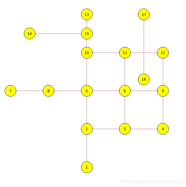
原始节点和路网
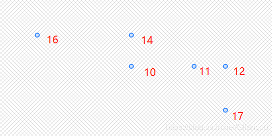
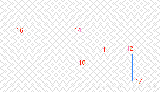
修改后的节点点和路网
四、数据查询
pgr_dijkstra算法:
# 查看节点16到节点17经过节点
SELECT * FROM pgr_dijkstra(
 'SELECT id, source, target, cost, reverse_cost FROM edge_table',
  16, 17,directed := FALSE) as dijkstra LEFT JOIN edge_table_vertices_pgr as etvg ON (dijkstra.node = etvg.id) ORDER BY seq;
结果:
# 查看节点16到节点17路径
SELECT * FROM pgr_dijkstra(
 'SELECT id, source, target, cost, reverse_cost FROM edge_table',
  16, 17,directed := FALSE) as dijkstra LEFT JOIN edge_table as et ON (dijkstra.edge = et.id) ORDER BY seq;
结果:
获取节点几何对象:
# 例如,要取edge_table_vertices_pgr编号为17的节点。
SELECT st_astext(the_geom) FROM edge_table_vertices_pgr WHERE id=17
# 取edge编号为17的边。
SELECT st_astext(the_geom) FROM edge_table WHERE id=17
捕获最近节点:
# pgr_dijkstra函数入参,需要输入节点编号,并不支持坐标入参。
# 大多数情况下,路径规划的起终点都不在节点上。
# 这时候需要做的是,先获取节点的编号。
# 根据坐标x,y从edge_table_vertices_pgr中获取一个在点(x,y)半径0.1内的点,并返回该点的节点id属性。
# 用获取的节点,就可以使用pgr_dijkstra了。
SELECT id FROM edge_table_vertices_pgr WHERE st_dwithin(the_geom, st_makePoint(x,y),0.1)=true limit 1
# 还可以直接传入点坐标使用pgr_dijkstra
SELECT * FROM
(SELECT id FROM edge_table_vertices_pgr WHERE st_dwithin(the_geom, st_makePoint(3.5,4),0.1)=true limit 1) t1,
(SELECT id FROM edge_table_vertices_pgr WHERE st_dwithin(the_geom, st_makePoint(3.5,2.3),0.1)=true limit 1) t2,
pgr_dijkstra(
 'SELECT id, source, target, cost, reverse_cost FROM edge_table',
 t1.id,t2.id,directed := FALSE) as dijkstra LEFT JOIN edge_table as et ON (dijkstra.edge = et.id) ORDER BY seq;
 # 传入三个坐标
(SELECT * FROM
(SELECT id FROM new_edge_table_vertices_pgr WHERE st_dwithin(the_geom, st_makePoint(0.5,3.5),0.1)=true limit 1) t1,
(SELECT id FROM new_edge_table_vertices_pgr WHERE st_dwithin(the_geom, st_makePoint(2,3),0.1)=true limit 1) t2,
pgr_dijkstra(
 'SELECT id, source, target, cost, reverse_cost FROM new_edge_table',
 t1.id,t2.id,directed := FALSE) as dijkstra LEFT JOIN new_edge_table as et ON (dijkstra.edge = et.id) where edge != '-1' ORDER BY seq)
UNION ALL
(SELECT * FROM
(SELECT id FROM new_edge_table_vertices_pgr WHERE st_dwithin(the_geom, st_makePoint(2,3),0.1)=true limit 1) t2,
(SELECT id FROM new_edge_table_vertices_pgr WHERE st_dwithin(the_geom, st_makePoint(3.5,2.3),0.1)=true limit 1) t3,
pgr_dijkstra(
 'SELECT id, source, target, cost, reverse_cost FROM new_edge_table',
 t2.id,t3.id,directed := FALSE) as dijkstra LEFT JOIN new_edge_table as et ON (dijkstra.edge = et.id) where edge != '-1' ORDER BY seq)


