Elasticsearch实战——地理位置查询
文章目录
为了方便学习ES的地理位置查询,这里准备了一些地理坐标为测试数据,每一条数据都包含城市名称和地理坐标两个字段。首先把下面的内容保存到
geo.json文件中:
{"index":{"_index":"geo","_id":"1"}}
{"city":"北京","localtion":"40.019559,116.312282"}
{"index":{"_index":"geo","_id":"2"}}
{"city":"乌鲁木齐","localtion":"43.863737,87.53891"}
{"index":{"_index":"geo","_id":"3"}}
{"city":"西安","localtion":"34.43376,108.879774"}
{"index":{"_index":"geo","_id":"4"}}
{"city":"郑州","localtion":"34.76845,113.589482"}
{"index":{"_index":"geo","_id":"5"}}
{"city":"杭州","localtion":"30.345351,120.102125"}
{"index":{"_index":"geo","_id":"6"}}
{"city":"济南","localtion":"36.688506,117.158558"}
{"index":{"_index":"geo","_id":"7"}}
{"city":"上海","localtion":"31.298035,121.426731"}
{"index":{"_index":"geo","_id":"8"}}
{"city":"武汉","localtion":"30.632158,114.28858"}
{"index":{"_index":"geo","_id":"9"}}
{"city":"广州","localtion":"23.150725,113.221536"}
然后创建一个索引:
PUT geo
{
  "settings": {
    "number_of_shards": "1",
    "number_of_replicas": "0"
  },
  "mappings": {
    "properties": {
      "city": {
        "type": "keyword"
      },
      "location": {
        "type": "geo_point"
      }
    }
  }
}
再执行:
$curl -X POST "localhost:9200/_bulk?pretty" -H 'Content-Type: application/json' --data-binary @geo.json
1. 半径查询(geo_distance query)
geo_distance query可以查找在一个中心点指定半径范围内的地理文档。例如查询距离天津500km以内的城市,搜索结果会返回北京、济南,命令如下:
{
	"query":{
		"bool":{
			"must":{
				"match_all":{}
			},
			"filter":{
				"geo_distance":{
					"distance":"500km",
					"location":{
						"lat":"38.993443",
						"lon":"117.158558"
					}
				}
			}
		}
	}
}
按距离天津的距离排序:
{
  "query": {
    "bool": {
      "must": {
        "match_all": {}
      },
      "filter": {
        "geo_distance": {
          "distance": "500km",
          "location": {
            "lat": "38.993443",
            "lon": "117.158558"
          }
        }
      }
    }
  },
  "sort": [
    {
      "_geo_distance": {
        "location": {
          "lat": "38.993443",
          "lon": "117.158558"
        },
        "unit": "km"
      }
    }
  ]
}
2. 指定矩形内的查询(geo_bounding_box query)
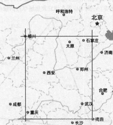
geo_bounding_box query用于查询落入指定的矩形内的地理坐标。查询中由两个点确定一个矩形,如图中的银川和南昌,在这两个点上分别做垂线(经度)和平行线(维度),相交线会组成一个矩形区域,可以查询到西安、郑州、武汉。
左上角和右下角查询
{
	"query":{
		"bool":{
			"must":{
				"match_all":{}
			},
			"filter":{
				"geo_bounding_box":{
					"location":{
						"top_left":{
							"lat":"38.532499",
							"lon":"106.193769"
						},
						"bottom_right":{
							"lat":"28.671728",
							"lon":"115.907542"
						}
					}
				}
			}
		}
	}
}
左下角和右上角查询
{
  "query": {
    "bool": {
      "must": {
        "match_all": {}
      },
      "filter": {
        "geo_bounding_box": {
          "location": {
            "top_right": {
              "lat": "40.807062",
              "lon": "119.108671"
            },
            "bottom_left": {
              "lat": "22.12604",
              "lon": "101.741623"
            }
          }
        }
      }
    }
  }
}
3. 查询指定多边形内的数据(geo_polygon query)
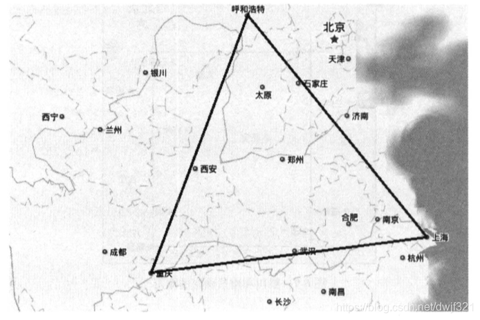
geo_polygon query用于查找指定多边形内的地理点。例如,呼和浩特、重庆、上海三地组成的三角形,查询位置在改三角形区域内的城市。
{
	"query":{
		"bool":{
			"must":{
				"match_all":{}
			},
			"filter":{
				"geo_polygon":{
					"location":{
						"points":[
							{"lat":"40.835015","lon":"111.712958"},
							{"lat":"29.640695","lon":"106.561715"},
							{"lat":"31.23482","lon":"121.50032"}
						]
					}
				}
			}
		}
	}
}
4 查询geo_shape类型的数据(geo_shape query)
geo_shapequery用于查询geo_shape类型的地理数据,地理形状之间包含的关系有:相交、包含、不相交三种。创建一个新的索引用于测试,其中location字段的类型设置为geo_shape类型:
PUT geoshape
{
  "settings": {
    "number_of_shards": "1",
    "number_of_replicas": "0"
  },
  "mappings": {
    "properties": {
      "city": {
        "type": "keyword"
      },
      "location": {
        "type": "geo_shape"
      }
    }
  }
}
geo_point类型的字段是:纬度在前,经度在后,但是geo_shape类型中的点是:经度在前,纬度在后。这点需要特别注意。
POST geoshape/_doc/1
{
	"city":"西安-郑州",
	"location":{
		"type":"linestring",
		"coordinates":[
			[108.953364,34.372762],
			[113.626277,34.76845]
		]
	}
}
查询包含在由银川和南昌组成的矩形的地理形状内的数据,由于西安和郑州组成的直线落在该矩形区域内,因此可以被查询到。
{
	"query":{
		"bool":{
			"must":{
				"match_all":{}
			},
			"filter":{
				"geo_shape":{
					"location":{
						"shape":{
							"type":"envelope",
							"coordinates":[
								[106.230564,38.50359],
								[115.870747,28.704175]
							]
						},
						"relation":"within"
					}
				}
			}
		}
	}
}
5. 关注我
搜索微信公众号:java架构强者之路


