GF1卫星信息整理
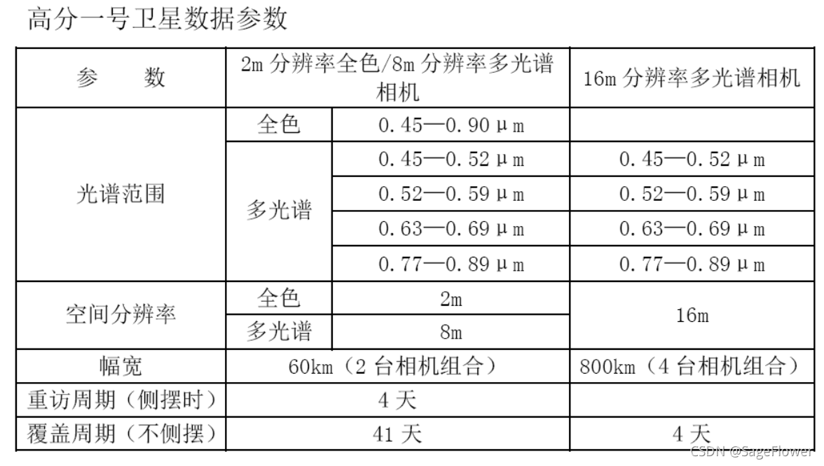
- 高分1号
- 高分1 BCD星
- pitch yaw roll解析
- 经纬度坐标生成多边形kml,shp文件
- aircas内网上GF1号卫星命名方式,metadata里是否包含satellite roll angel(matlab程序)
- GDAL bigtiff
- 注册中国资源卫星应用中心
- 爬取数据遥感所内网影像的程序
- 爬取自然资源卫星应用中心
- matlab对txt文件字符串替换,改文件后缀名
- 遥感所内网等需按区域所需要的shp文件怎么设置
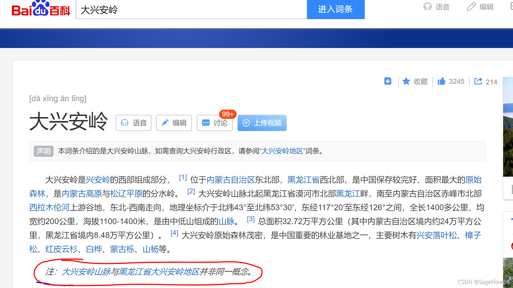
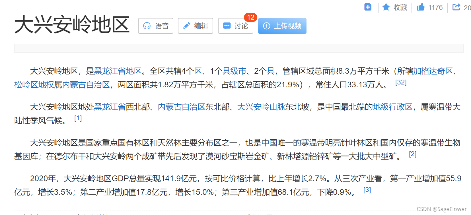
- 大兴安岭VS大兴安岭地区
- 大兴安岭光学影像(google_earth地图)
- arcgis如何创建dxalshapfile文件:
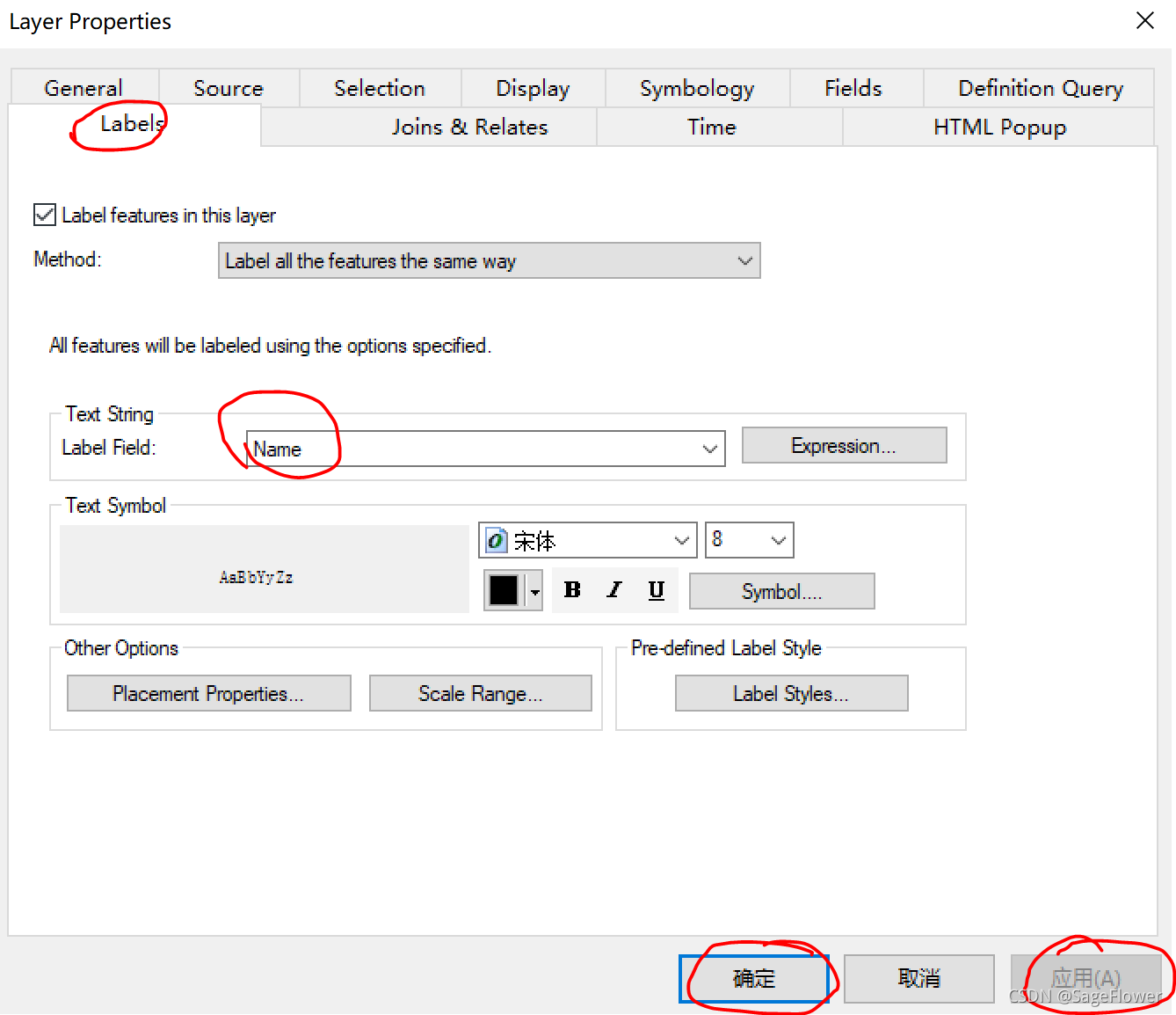
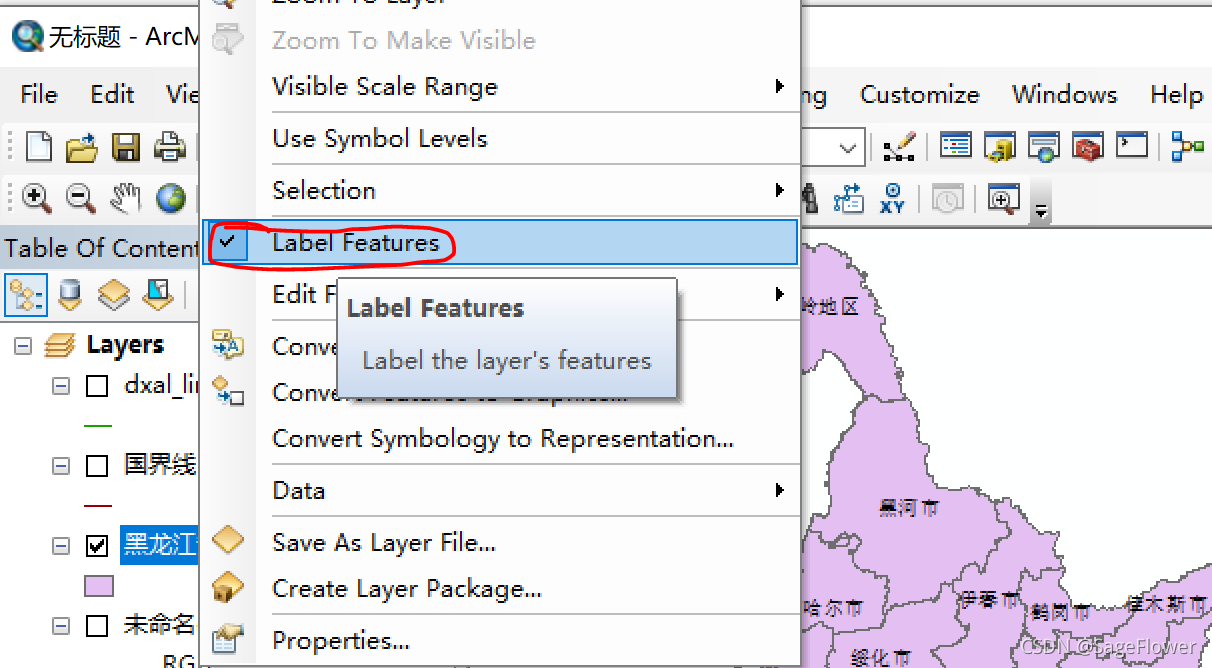
- arcgis 怎么显示图层特征(多边形名称)
- matlab
- UTM坐标系的相关内容
- python一些技巧
- cmd进入D
仅做自己记录
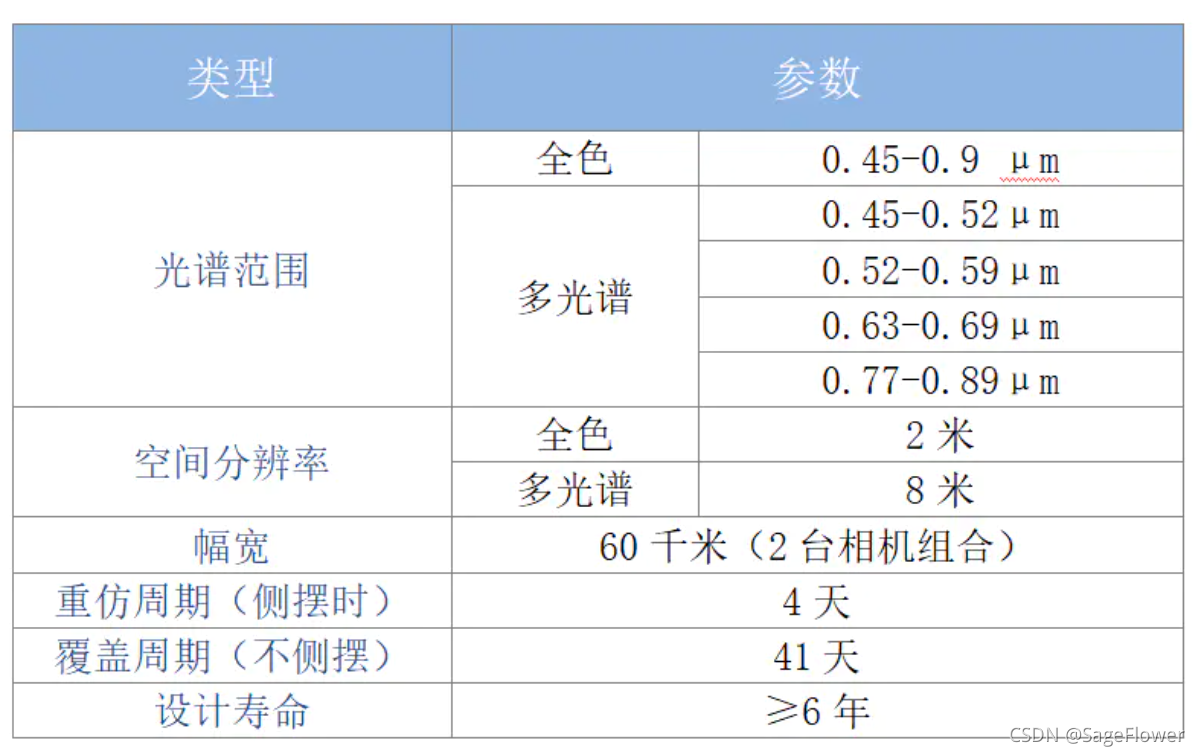
高分1号
https://www.sohu.com/a/202609956_637217
高分1 BCD星
https://www.jianshu.com/p/df4a5c5e4f58
pitch yaw roll解析
https://blog.csdn.net/guyubit/article/details/52995676
经纬度坐标生成多边形kml,shp文件
使用simplekml的python库
参考网址:https://www.cnpython.com/qa/505798
https://www.pythonheidong.com/blog/article/1066606/52d6eba4bde63a9416a2/
https://vimsky.com/examples/detail/python-method-simplekml.Kml.html
http://cn.voidcc.com/question/p-gkrkfdha-ma.html
https://www.cnpython.com/qa/119407
https://www.zhihu.com/zvideo/1347226150465306624
安装simplekml库
https://blog.csdn.net/qq_16583687/article/details/68951790
https://www.cnpython.com/pypi/simplekml/dl-simplekml-1.3.5-py3-none-any.whl
aircas内网上GF1号卫星命名方式,metadata里是否包含satellite roll angel(matlab程序)
(1)命名方式:
(2)检查meta data是否包含satellite roll angel
fclose all
clear all
clc

filepath='F:\GF\GF-1_ininternet\GF1_yao\';
files = dir(filepath);
size0 = size(files);
length = size0(1);
%names = files(3:length);
%class_num = size(names);
for i=3:length
   fileName = strcat(filepath,files(i,1).name);
   names(:,:,i-2) = char(fileName);
end
class_num = size(names);
for j=1:class_num(3)
xml_file=dir([[names(1,:,j),'\'],'*.meta.xml']);
% read xml file
xmlDoc = xmlread([xml_file.folder,'\',xml_file.name]);
%read RollSatelliteAngel
phone_array = xmlDoc.getElementsByTagName('RollSatelliteAngle');
phone = phone_array.item(0);
% does the meta file have the rollsatelliteangel?
if isempty(phone)==0  % yes,it does.  print the file name into the have_yaw_angel.txt
%disp(char(phone.getTextContent()));
fid=fopen('D:\have_yaw_angel.txt','a');
fprintf(fid,'%7s %7s\r\n',xml_file.name,char(phone.getTextContent()) );
fclose(fid);
else % no ,print the file name into the dont_have_yaw_angel.txt
fid=fopen('D:\dont_have_yaw_angel.txt','a');
fprintf(fid,'%7s\r\n',xml_file.name);
fclose(fid);
end

end
GDAL bigtiff
(1)简单理解是:bigtiff是tiff的变种,适用于影像大于4GB的情况。
参考链接:https://blog.csdn.net/u014311125/article/details/105778268
官方链接(推荐):https://gdal.org/drivers/raster/gtiff.html
注册中国资源卫星应用中心
http://36.112.130.153:7777/DSSPlatform/shirologin.html
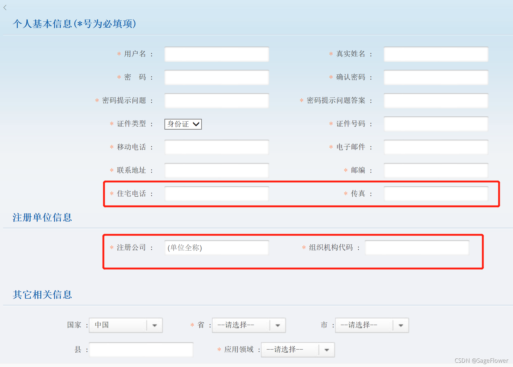
因为注册需要填很多信息,包括一些并不知道怎么填的必填信息,像下面红框里的。后来,因为自己属于空天院,发现空天院的这方面信息都是公开可获得的。
空天院电话:010-82177608
传真:010-82178009
空天院单位全称:中国科学院空天信息创新研究院
组织机构代码:12100000MB1E85344J
爬取数据遥感所内网影像的程序
https://blog.csdn.net/qq_34965596/article/details/102814192
https://www.sojson.com/simple_json.html
https://blog.csdn.net/weixin_42210687/article/details/103480208
第一步:爬取遥感所内网的影像:
from pprint import pprint

import requests  # 导入requests包
import json
import time


def get_date(num=None):
    headers = {
        'User-Agent': "Mozilla/5.0 (Windows NT 10.0; WOW64) AppleWebKit/537.36 (KHTML, like Gecko) Chrome/86.0.4240.198 Safari/537.36",
        'Accept-Language': "zh-CN,zh;q=0.9",
        'Cookie': 'td_cookie=1800153597; JSESSIONID=52F8F0201F668756C78BF7413FB86365; td_cookie=1793278618; _pk_ref.34.ff60=%5B%22%22%2C%22%22%2C1636641473%2C%22http%3A%2F%2Flogindataservices.ceode.ac.cn%2Fweb%2Fuserreg%22%5D; _pk_testcookie.34.ff60=1; _pk_id.34.ff60=63fbe21024296aab.1635731779.31.1636641473.1636641473.; _pk_ses.34.ff60=1'
            }
    url = 'http://ids.ceode.ac.cn/gfds/contract/query/list'
    From_data = {
        "fromDate": "2013-04-26",
        "toDate": "2021-11-03",
        "symbol": "",
        "querytimemode": "imagetime",
        "imagemode": "",
        "orbitsense": "",
        "NAD": "1",
        "FWD": "1",
        "BWD": "1",
        "productid": "",
        "productlevel": "",
        "cloudcoveravg": "0.5",
        "pageSize": num,
        "pageNumber": "1",
        "sortName": "begintime",
        "sortOrder": "desc",
        "sensorlist[]": "'GF01';'PA1', 'PA2', 'PM1', 'PM2'",
        #"sensorlist[]": "'GF01';'PM1', 'PM2'",
        #"sensorlist[]":"'GF1BCD';'PAN'",
        #"sensorlist[]": "'GF01';'PA1', 'PA2', 'PM1', 'PM2'",
        "area_id": "0",
        "spatialClause": '{"type":"polygon","coordinates":[[[120.68392676506365,49.53215484219334],[119.43148535881399,50.70149673127322],[120.11263770256382,51.76086468296725],[120.61800879631369,52.07257906055418],[120.48617285881372,52.48929742611664],[119.82699317131389,52.55614336917213],[120.0906650463138,52.92860329922983],[121.29916114006349,53.57276965872703],[123.82601660881282,53.65098156977507],[125.6058017650624,53.166363216326765],[126.48470801506215,52.68953025731929],[126.74837989006208,51.99147086180133],[126.96810645256203,51.44698331765673],[124.28744239006274,48.45087722164997],[122.09017676506332,46.187240137132555],[120.02474707756386,46.1568082068753],[119.62923926506397,46.732136323857574],[119.18978614006409,47.83509275112183],[120.50814551506373,49.317775795934246],[120.68392676506365,49.53215484219334]]]}'
        #"spatialClause": '{"type": "polygon", "coordinates": [[[113.3593749999949, 42.127005882097244], [115.6445312499943, 42.127005882097244],[115.6445312499943, 40.67673648795837], [113.3593749999949, 40.67673648795837],[113.3593749999949, 42.127005882097244]]]}'
    }
    # 请求表单数据
    response = requests.post(url, data=From_data, headers=headers, verify=False)
    # response = requests.post(url, headers=headers, verify=False)
    # response = requests.post(url, verify=False)
    # 将Json格式字符串转字典
    print(response.raw)
    content = json.loads(response.text)
    # content = response.text
    pprint(content)
    # with open("./data.txt", "w") as f:
    #     f.write(str(content))

    temp_num_data=content['rows']
    for i, meta in enumerate(temp_num_data[2426:2427]):
    #for i, meta in enumerate(content['rows']):
        m_url = 'http://ids.ceode.ac.cn/gfds' + meta['metafilename']
        time.sleep(0.1)
        res = requests.get(url=m_url, headers=headers)
        print(res.text)

        # 把所有获取的meta信息写入到一个meta_data.txt文件里面
        #with open('meta_data.txt', 'a', encoding='utf-8') as f:
        #    f.writelines("第{}个:\n".format(i + 1))
        #    f.write(res.text)
        #    f.writelines("")

        #把所有获取的meta信息写入到不同的txt文件里。文件命名为影像的id。
        my_str = meta['metafilename']
        strlist = my_str.split('/')  # 用逗号分割str字符串,并保存到列表
        #print(strlist[4])
        temp_meta_file_name =strlist[4]+ '.txt'
        with open(temp_meta_file_name, 'w', encoding='utf-8') as f:
            #f.writelines("第{}个:\n".format(i+1))
            f.write(res.text)
            f.writelines("")


if __name__ == '__main__':
    get_date(2426)
第二步 预处理等步骤(matlab)
%第一部分:将获取的txt文件中一些特定字符改为xml的字符 < >
%第二部分:将txt文件后缀名改为xml
%第三部分:将这些所有的txt文件,改为后缀为xml的文件
%第四部分:将所有的文件按是否包含RollSatelliteAngle开
%第五部分:提取所有影像元数据信息,并以 经度_纬度_年月日_SatelliteRollAngel_影像原始文件名记录下来。
clc
clear all
close all
%% 将获取的txt文件中一些特定字符改为xml的字符 < >
file_path='D:\dxal_polygon_search\dxal_search3\';
files = dir(file_path);
size0 = size(files);
length = size0(1);
for i=3:length
fileName = strcat(file_path,files(i,1).name);
fid=fopen(fileName);
count=1;
str=[];
while ~feof(fid)
tline = fgetl(fid);
str{count}=tline;
count=count+1;
end
fclose(fid);
for j=1:(count-1)
str{j}=strrep(str{j},'<','<');
str{j}=strrep(str{j},'?>','?>');
str{j}=strrep(str{j},'>','>');
end
%% 把替换好的str写入到原来txt文件里。
fid=fopen(fileName,'w');
for z=1:(count-1)
fprintf(fid,'%7s\r\n',str{z});
end
fclose(fid);
%% 将这些所有的txt文件,改为后缀为xml的文件
newName=[fileName(1:end-4) '.xml'];
movefile(fileName,newName);%移入新扩展名的文件中
end
%% 按metadata是否包含RollSatelliteAngle分为两部分
files = dir(file_path);
size0 = size(files);
length = size0(1);
%names = files(3:length);
%class_num = size(names);
% for i=3:length
% fileName = strcat(filepath,files(i,1).name);
% names(:,:,i-2) = char(fileName);
% end
% class_num = size(names);
xml_file=dir([file_path,'*.xml']);
for p=1:length-2
xmlDoc = xmlread([xml_file(p).folder,'\',xml_file(p).name]);
% read xml file
%xmlDoc = xmlread([char(p),'.xml']);
%read RollSatelliteAngel
phone_array = xmlDoc.getElementsByTagName('RollSatelliteAngle');
phone = phone_array.item(0);
% does the meta file have the rollsatelliteangel?
if isempty(phone)==0 % yes,it does. print the file name into the have_yaw_angel.txt
%disp(char(phone.getTextContent()));
%fid=fopen('D:\dxal_polygon_search\dxal_search1\have_yaw_angel.txt','a');
fid=fopen([file_path,'have_yaw_angel.txt'],'a')
fprintf(fid,'%7s\r\n',xml_file(p).name);
fclose(fid);
else % no ,print the file name into the dont_have_yaw_angel.txt
%fid=fopen('D:\dxal_polygon_search\dxal_search1\dont_have_yaw_angel.txt','a');
fid=fopen([file_path,'dont_have_yaw_angel.txt'],'a');
fprintf(fid,'%7s\r\n',xml_file(p).name);
fclose(fid);
end
end
%% 第五部分:提取所有影像元数据信息,并以 经度_纬度_年月日_SatelliteRollAngel_影像原始文件名记录下来。
% 逐行读取txt文件的内容
第三步 修改名称
% 将有roll角的GF1影像按着经度_纬度_年月日_StelliteRollAngel_影像id 记录下来
fclose all
clear all
clc

file_path='D:\dxal_polygon_search\dxal_search3\';
%fid = fopen('D:\matlab测试\have_yaw_angel.txt');
fid = fopen([file_path,'have_yaw_angel.txt']);
tline = fgetl(fid);
i=0;
while ischar(tline)
i=i+1;
%disp(tline);
xml_file_name=[file_path,tline];
%xmlDoc=xmlread('D:\matlab测试\GF01_PA2_041390_20201230_MY941_01_035_L1A_01.xml');
xmlDoc=xmlread(xml_file_name);
% name node
SceneCenterLat = xmlDoc.getElementsByTagName('SceneCenterLat');
SceneCenterLat_num = char(SceneCenterLat.item(0).getTextContent());
%disp(['SceneCenterLat:' SceneCenterLat_num]);
SceneCenterLong = xmlDoc.getElementsByTagName('SceneCenterLong');
SceneCenterLong_num = char(SceneCenterLong.item(0).getTextContent());
%disp(['SceneCenterLong:' SceneCenterLong_num]);
ProductID = xmlDoc.getElementsByTagName('ProductID');
ProductID_num = char(ProductID.item(0).getTextContent());
%disp(['ProductID:' ProductID_num]);
RollSatelliteAngle = xmlDoc.getElementsByTagName('RollSatelliteAngle');
RollSatelliteAngle_num = char(RollSatelliteAngle.item(0).getTextContent());
%disp(['RollSatelliteAngle:' RollSatelliteAngle_num]);
image_get_time=strsplit(ProductID_num,'_');
need_record_info=[SceneCenterLong_num,'_',SceneCenterLat_num,'_',char(image_get_time(4)),'_',RollSatelliteAngle_num,'_',ProductID_num];
%disp(need_record_info);

%have_roll_angel_image_txt=fopen('D:\matlab测试\have_roll_angel_image.txt','a');
have_roll_angel_image_txt=fopen([file_path,'have_roll_angel_image.txt'],'a');
fprintf(have_roll_angel_image_txt,'%7s\r\n',need_record_info);
fclose(have_roll_angel_image_txt);
tline = fgetl(fid);
disp(i);
end
fclose(fid);
第四步 选取符合条件的影像对(matlab)
% 筛选可能合适的影像对   按位置进行筛选
fclose all
clear all
clc

file_path='D:\dxal_polygon_search\dxal_search1\';
%fid1 = fopen('D:\matlab测试\have_roll_angel_image.txt');
fid1 = fopen([file_path,'have_roll_angel_image.txt']);
tline1 = fgetl(fid1);
yuzhi_lon=0.1;
yuzhi_lat=0.1;
num_file1=0;
count=0;
file1_count=0;
load_file1=load([file_path,'have_roll_angel_image.txt']);
size_file1=size(load_file1);
while ischar(tline1)
    if file1_count > size_file1(1)/2+1
        break
    end
    %disp(tline1);
    num_file1=num_file1+1;
    file1_info=strsplit(tline1,'_');
    file1_lon=str2num(char(file1_info(1)));
    file1_lat=str2num(char(file1_info(2)));
    file1_roll_angel=str2num(char(file1_info(4)));
    %fid2=fopen('D:\matlab测试\have_roll_angel_image_copy.txt');
    fid2=fopen([file_path,'have_roll_angel_image_copy.txt']);
    tline2=fgetl(fid2);
    num_file2=0;
    while ischar(tline2)

        num_file2=num_file2+1;
        file2_info=strsplit(tline2,'_');
        file2_lon=str2num(char(file2_info(1)));
        file2_lat=str2num(char(file2_info(2)));
        file2_roll_angel=str2num(char(file2_info(4)));
        deta_lon=abs(file1_lon-file2_lon);
        deta_lat=abs(file1_lat-file2_lat);
        deta_roll_angel=abs(file1_roll_angel-file2_roll_angel);
%         if num_file1 ~= num_file2
%             if deta_lon < yuzhi_lon
%                 if deta_lat <yuzhi_lat
%                     if deta_roll_angel > 5
%                        %record_fid=fopen('D:\matlab测试\possible_image_pairs.txt','a');
%                         record_fid=fopen([file_path,'possible_image_pairs.txt'],'a');
%                         fprintf(record_fid,'%7s %7s\r\n',tline1,tline2);
%                         fclose(record_fid);
%                     end
%                 end
%             end
%         end


        if num_file1 ~= num_file2 && deta_lon < yuzhi_lon && deta_lat<yuzhi_lat && deta_roll_angel >20
            %record_fid=fopen([file_path,'possible_image_pairs.txt'],'a');
            record_fid=fopen([file_path,'possible_rollangel_gt25_image_pairs.txt'],'a');
            fprintf(record_fid,'%7s %7s\r\n',tline1,tline2);
            fclose(record_fid);


% %             count=count+1;
%               if strcmp(char(file1_info(5)),'GF01')==1
%                   need_download_file1=[char(file1_info(5)),'_',char(file1_info(6)),'_',char(file1_info(7)),'_',char(file1_info(8)),'_',char(file1_info(9)),'_',char(file1_info(10)),'_',char(file1_info(11)),'_',char(file1_info(12)),'_',char(file1_info(13))];
%               else
%                   need_download_file1=[char(file1_info(5)),'_',char(file1_info(6)),'_',char(file1_info(7)),'_',char(file1_info(8)),'_',char(file1_info(9)),'_',char(file1_info(10)),'_',char(file1_info(11)),'_',char(file1_info(12))];
%
%               end
%               if strcmp(char(file2_info(5)),'GF01')==1
%                   need_download_file2=[char(file2_info(5)),'_',char(file2_info(6)),'_',char(file2_info(7)),'_',char(file2_info(8)),'_',char(file2_info(9)),'_',char(file2_info(10)),'_',char(file2_info(11)),'_',char(file2_info(12)),'_',char(file2_info(13))];
%               else
%                   need_download_file2=[char(file2_info(5)),'_',char(file2_info(6)),'_',char(file2_info(7)),'_',char(file2_info(8)),'_',char(file2_info(9)),'_',char(file2_info(10)),'_',char(file2_info(11)),'_',char(file2_info(12))];
%
%               end
%
%              need_download_fid=fopen([file_path,'need_download_file.txt'],'a');
%              fprintf(need_download_fid,['%7s',',','%7s',','],need_download_file1,need_download_file2);
%              fclose(need_download_fid);

        end

        tline2=fgetl(fid2);
    end
    fclose(fid2);
    tline1 = fgetl(fid1);
    file1_count=file1_count+1;

end
fclose(fid1);
爬取自然资源卫星应用中心
第一步 爬取影像,meta .html
(注意:此网站影像的命名规则,product id 唯一确定一张影像)
from pprint import pprint

import requests  # 导入requests包
import json
import time
import numpy as np
import re

# 一些需要修改的变量
#v_Cookie='',
#v_url='http://36.112.130.153:7777/KQGis/rest/services/GF1/MapServer/Query',    #确定选取的是哪一种传感器类型的卫星(GF6  GF1  GF1B   GF1C   GF1D?)
#v_geometry='{"type":"PolyGon","rings":[[[120.20414115423888,49.322944195365714],[120.18512677602973,50.26088835965418],[119.3191010751725,50.674115594540396],[120.04640104167767,51.69577930222572],[120.61683238795649,52.14768164587974],[120.50274611870077,52.322794930483205],[120.56929644243314,52.51461829831373],[119.94182196152678,52.53201521454525],[119.9133003942128,52.78061077928981],[120.77845460273532,53.32480864660704],[122.35664799410607,53.55754345580476],[123.4214531738262,53.648019586215234],[125.89458996624718,53.077434565613764],[126.56009320357224,52.46625719403239],[127.20658206268797,51.08636216252175],[123.92739408734495,48.72900554611164],[122.04367450588052,46.28045687825926],[120.9647162826103,44.028602584693886],[118.11255955121747,42.955794538140765],[116.7340171310442,43.02558700023069],[116.87662496761368,44.062889677522996],[119.21047973633256,46.64274978636518],[119.44356602586743,48.22330866611077],[120.20414115423888,49.322944195365714]]]}'  #确定选取的区域,可是是shp,经纬度,图形框选等。
v_geometry='{"type":"PolyGon","rings":[[[120.20414115423888,49.322944195365714],[120.18512677602973,50.26088835965418],[119.3191010751725,50.674115594540396],[120.04640104167767,51.69577930222572],[120.61683238795649,52.14768164587974],[120.50274611870077,52.322794930483205],[120.56929644243314,52.51461829831373],[119.94182196152678,52.53201521454525],[119.9133003942128,52.78061077928981],[120.77845460273532,53.32480864660704],[122.35664799410607,53.55754345580476],[123.4214531738262,53.648019586215234],[125.89458996624718,53.077434565613764],[126.56009320357224,52.46625719403239],[127.20658206268797,51.08636216252175],[123.92739408734495,48.72900554611164],[122.04367450588052,46.28045687825926],[120.9647162826103,44.028602584693886],[118.11255955121747,42.955794538140765],[116.7340171310442,43.02558700023069],[116.87662496761368,44.062889677522996],[119.21047973633256,46.64274978636518],[119.44356602586743,48.22330866611077],[120.20414115423888,49.322944195365714]]]}'
#v_fields='UFJPRFVDVElELE9CSkVDVElELE1FVEFEQVRBSUQsU0FURUxMSVRFSUQsU0VOU09SSUQsUkVDRUlWRVNUQVRJT05JRCxTQ0VORURBVEUsQ0VOVEVSTE9OR0lUVURFLENFTlRFUkxBVElUVURFLFRPUExFRlRMT05HSVRVREUsVE9QTEVGVExBVElUVURFLFRPUFJJR0hUTE9OR0lUVURFLFRPUFJJR0hUTEFUSVRVREUsQk9UVE9NUklHSFRMT05HSVRVREUsQk9UVE9NUklHSFRMQVRJVFVERSxCT1RUT01MRUZUTE9OR0lUVURFLEJPVFRPTUxFRlRMQVRJVFVERSxUSFVNQkZJTEVMT0NBVElPTixCUk9XU0VGSUxFTE9DQVRJT04sU0NFTkVQQVRILFNDRU5FUk9XLElTUkVMRUFTRSxTQ0VORUlELFBST0RVQ1RMRVZFTCxTVFJJUElELERJUkVDVElPTixTSEFQRQ=='
v_fields='UFJPRFVDVElELE9CSkVDVElELE1FVEFEQVRBSUQsU0FURUxMSVRFSUQsU0VOU09SSUQsUkVDRUlWRVNUQVRJT05JRCxTQ0VORURBVEUsQ0VOVEVSTE9OR0lUVURFLENFTlRFUkxBVElUVURFLFRPUExFRlRMT05HSVRVREUsVE9QTEVGVExBVElUVURFLFRPUFJJR0hUTE9OR0lUVURFLFRPUFJJR0hUTEFUSVRVREUsQk9UVE9NUklHSFRMT05HSVRVREUsQk9UVE9NUklHSFRMQVRJVFVERSxCT1RUT01MRUZUTE9OR0lUVURFLEJPVFRPTUxFRlRMQVRJVFVERSxUSFVNQkZJTEVMT0NBVElPTixCUk9XU0VGSUxFTE9DQVRJT04sU0NFTkVQQVRILFNDRU5FUk9XLElTUkVMRUFTRSxTQ0VORUlELFBST0RVQ1RMRVZFTCxTVFJJUElELERJUkVDVElPTixTSEFQRQ=='
#v_where='IGNsb3VkcGVyY2VudCA8PSAxIGFuZCBTQ0VORURBVEUgPiA9MjAyMTExMTUgYW5kIFNDRU5FREFURSA8PTIwMjExMTE2IGFuZCBzZW5zb3JpZCBpbignUE1TMScsJ1BNUzInKSBhbmQgSVNSRUxFQVNFID0gJ1RSVUUn'
v_where='IGNsb3VkcGVyY2VudCA8PSAxIGFuZCBTQ0VORURBVEUgPiA9MjAxMzA0MjYgYW5kIFNDRU5FREFURSA8PTIwMjExMTE2IGFuZCBzZW5zb3JpZCBpbignUE1TMScsJ1BNUzInKSBhbmQgSVNSRUxFQVNFID0gJ1RSVUUn'
v_detail_url='http://36.112.130.153:7777/DSSPlatform/scene/sceneview.html'
v_sateliteid='GF1'
#v_sensorid= 'PMS1'
v_layers='WllXWC5NRVRBX0dGMV8x'

def get_date(num=None):
    headers = {
        'Accept': 'text/html,application/xhtml+xml,application/xml;q=0.9,image/avif,image/webp,image/apng,*/*;q=0.8,application/signed-exchange;v=b3;q=0.9',
        'Accept-Encoding': 'gzip,deflate',
        'Accept-Language': "zh-CN,zh;q=0.9",
        'Content-Length': '90',
        'Content-Type': 'application/x-www-form-urlencoded',
        'Host': '36.112.130.153:7777',
        'Origin': 'http://36.112.130.153:7777',
        'Proxy-Connection': 'keep-alive',
        'User-Agent': 'Mozilla/5.0 (Windows NT 10.0; WOW64) AppleWebKit/537.36 (KHTML, like Gecko) Chrome/86.0.4240.198 Safari/537.36',
    }

    url = 'http://36.112.130.153:7777/KQGis/rest/services/GF1/MapServer/Query'

    From_data = {

        'base64': '1',
        'page': '0',
        'pageSize': num,
        'geometry':v_geometry,
        'fields':v_fields,
        'where':v_where,
        'layers':v_layers,
        #'geometry': '{"type":"PolyGon","rings":[[[120.20414115423888,49.322944195365714],[120.18512677602973,50.26088835965418],[119.3191010751725,50.674115594540396],[120.04640104167767,51.69577930222572],[120.61683238795649,52.14768164587974],[120.50274611870077,52.322794930483205],[120.56929644243314,52.51461829831373],[119.94182196152678,52.53201521454525],[119.9133003942128,52.78061077928981],[120.77845460273532,53.32480864660704],[122.35664799410607,53.55754345580476],[123.4214531738262,53.648019586215234],[125.89458996624718,53.077434565613764],[126.56009320357224,52.46625719403239],[127.20658206268797,51.08636216252175],[123.92739408734495,48.72900554611164],[122.04367450588052,46.28045687825926],[120.9647162826103,44.028602584693886],[118.11255955121747,42.955794538140765],[116.7340171310442,43.02558700023069],[116.87662496761368,44.062889677522996],[119.21047973633256,46.64274978636518],[119.44356602586743,48.22330866611077],[120.20414115423888,49.322944195365714]]]}',
        #'fields': 'UFJPRFVDVElELE9CSkVDVElELE1FVEFEQVRBSUQsU0FURUxMSVRFSUQsU0VOU09SSUQsUkVDRUlWRVNUQVRJT05JRCxTQ0VORURBVEUsQ0VOVEVSTE9OR0lUVURFLENFTlRFUkxBVElUVURFLFRPUExFRlRMT05HSVRVREUsVE9QTEVGVExBVElUVURFLFRPUFJJR0hUTE9OR0lUVURFLFRPUFJJR0hUTEFUSVRVREUsQk9UVE9NUklHSFRMT05HSVRVREUsQk9UVE9NUklHSFRMQVRJVFVERSxCT1RUT01MRUZUTE9OR0lUVURFLEJPVFRPTUxFRlRMQVRJVFVERSxUSFVNQkZJTEVMT0NBVElPTixCUk9XU0VGSUxFTE9DQVRJT04sU0NFTkVQQVRILFNDRU5FUk9XLElTUkVMRUFTRSxTQ0VORUlELFBST0RVQ1RMRVZFTCxTVFJJUElELERJUkVDVElPTixTSEFQRQ==',
        #'layers': 'WllXWC5NRVRBX0dGNl8x',
        'unionGeometry': '1',
        #'where': 'IGNsb3VkcGVyY2VudCA8PSAxMDAgYW5kIFNDRU5FREFURSA+ID0yMDE5MTEwNSBhbmQgU0NFTkVEQVRFIDw9MjAyMTExMTIgYW5kIHNlbnNvcmlkIGluKCdQTVMnKSBhbmQgSVNSRUxFQVNFID0gJ1RSVUUn'
    }
    # 请求表单数据
    # response = requests.post(url, data=From_data, headers=headers, verify=False)
    # response = requests.post(url,  headers=headers)
    # response = requests.post(url, headers=headers, verify=False)
    response = requests.post(url, data=From_data, verify=False)
    # 将Json格式字符串转字典
    #print(response.text)
    content = json.loads(response.text)
    #print(content)
    allcount = int(content['allCount'])
    print(allcount)


    id = content['features'][0]['attributes']['PRODUCTID']
    #print(allcount,id)
    list_id = []

    id = content['features'][0]['attributes']['PRODUCTID']
    # print(allcount,id)
    list_id = []
    list_sensorid=[]
    list_product_level=[]
    list_satelliteid=[]
    list_sceneid=[]

    #print(content['features'][5990]['attributes'])
    #print(content['features'][6000]['attributes'])


    for i in range(allcount):
        list_id.append(content['features'][i]['attributes']['PRODUCTID'])
        list_sensorid.append(content['features'][i]['attributes']['SENSORID'])
        list_product_level.append(content['features'][i]['attributes']['PRODUCTLEVEL'])
        list_satelliteid.append(content['features'][i]['attributes']['SATELLITEID'])
        list_sceneid.append(content['features'][i]['attributes']['SCENEID'])
    #print(list_id)


    #url_detail = 'http://36.112.130.153:7777/DSSPlatform/scene/sceneview.html'

    def detail_form(id=None,sensorid=None,productlevel=None,satelliteid=None,sceneid=None):
        return {
            'productid': id,
            'sensorid':sensorid,
            'sceneid': sceneid,
            'method': 'view',
            'satelliteid': satelliteid,
            'productlevel': productlevel


        }
        #把所有获取的meta信息写入到一个meta_data.txt文件里面

    len_list_id = len(list_id)
    with open('D:/li_zi.txt', 'a', encoding='utf-8') as f:
        # f.writelines("第{}个:\n".format(i+1))
        #f.writelines(i)
        #f.write(str(np.array(list_id)))
        for i in list(range(0,len_list_id)):
            f.write(str(list_id[i]))
            f.write('\n')

    #print(list_id)

    print(len_list_id)
    #num_list=list(range(0,len_list_id,1))
    #new_list_id=[num_list,len_list_id]

    for i in list(range(10800,11000,1)):
        #print(i,id)
        #time.sleep(0.1)
        id=list_id[i]
        temp_sensorid=list_sensorid[i]
        temp_productlevel=list_product_level[i]
        temp_satelliteid=list_satelliteid[i]
        temp_sceneid=list_sceneid[i]

        response = requests.post(v_detail_url, headers=headers, data=detail_form(id,temp_sensorid,temp_productlevel,temp_satelliteid,temp_sceneid), verify=False)
        temp_meta_file_name ='D:/ziranziyuan3/'+str(id)+temp_sensorid+temp_productlevel+ '.html'
        #temp_meta_file_name = 'D:/ziranziyuan/' + str(id) + str(temp_sensorid) + str(temp_productlevel)+str(temp_satelliteid)+str(temp_sceneid) + '.html'
        #print(temp_meta_file_name)
        with open(temp_meta_file_name, 'w', encoding='utf-8') as f:
            f.write(response.text)


        if i % 100==0:
            time.sleep(15)


if __name__ == '__main__':
    get_date(20000)
第二步 对爬取的数据提取有用的表格里面的信息(meta信息),并为选取合适的影像对做准备
#import BeautifulSoup4
from bs4 import BeautifulSoup
# import bs4
#
import re
import numpy as np
import os

file_path='D:/dxal_ziranziyuanweixing_20130426_202111_15/'
record_txt_name='meta_file.txt'
dir_list_name=[]
list_ziranziyuanweixing=os.listdir(file_path)
for file_name in list_ziranziyuanweixing:
    #print(file_name)
    f=open(file_path+file_name,"r",encoding='utf-8')
    #print(file_path+file_name)
    #f = open("D:/ziranziyuan/1119940978.html","r",encoding='utf-8')
    html = f.read()
    table = re.findall(r'<table(.*?)</table>', html, re.S)#查找html中table之间的内容
    #print(table)

    ##################################################################################################
    #获取td1中的卫星相关信息
    nowtable=table[1]
    nowtable = nowtable.replace('\t','')#将空格换行等去除
    nowtable = nowtable.replace('\n','')
    nowtable = nowtable.replace(' ','')
    #print(nowtable)

    td1_info1=re.findall(r'class="tab_value">(.*?)</th>', nowtable, re.S)#成绩想关的信息都在tdclass="center"td之间
    #print(td1_info1)
    td1_info2 = re.findall(r'<tdclass="tab_value">(.*?)</td>', nowtable, re.S)#成绩想关的信息都在tdclass="center"td之间
    #print(td1_info1+td1_info2)
    td1_info=td1_info1+td1_info2
    td1_label=['卫星','传感器','采集时间','左上角经纬度','右上角经纬度','景中心经纬度','左下角经纬度','右下角经纬度','接收站','轨道圈号','景','星下点path/row','产品起始行时间','产品中间运行时间','产品结束运行时间']
    #print(td1_label)
    td1=[td1_label,td1_info]
    #print('/')
    td1_array=np.array(td1)
    #print(td1_array[:,0])
    #######################################################################################################
    #获取td2中的卫星相关信息
    nowtable=table[2]
    nowtable = nowtable.replace('\t','')#将空格换行等去除
    nowtable = nowtable.replace('\n','')
    nowtable = nowtable.replace(' ','')
    td2_info1=re.findall(r'class="tab_value">(.*?)</th>', nowtable, re.S)#成绩想关的信息都在tdclass="center"td之间
    #print(td2_info1)
    td2_info2 = re.findall(r'<tdclass="tab_value">(.*?)</td>', nowtable, re.S)#成绩想关的信息都在tdclass="center"td之间
    #print(td2_info1+td2_info2)
    td2_info=td2_info1+td2_info2
    td2_label=['产品级别','景序列号','产品序列号','生产日期','产品谱段','产品分辨率','产品类型','连续景数','浮动比例','产品格式','产品宽高(像素)','原始数据条带号','云覆盖量','产品大小','椭球模型','重采样方法','辐射校正方法','DEM数据来源','地图投影','投影带号','地球模型']
    #print(td1_label)
    td2=[td2_label,td2_info]
    #print('***************')
    td2_array=np.array(td2)
    #print(td2_array[:,12])

    #######################################################################################################
    #获取td3中的卫星相关信息
    nowtable=table[3]
    nowtable = nowtable.replace('\t','')#将空格换行等去除
    nowtable = nowtable.replace('\n','')
    nowtable = nowtable.replace(' ','')
    td3_info1=re.findall(r'class="tab_value">(.*?)</th>', nowtable, re.S)#成绩想关的信息都在tdclass="center"td之间
    #print(td3_info1)
    td3_info2 = re.findall(r'<tdclass="tab_value">(.*?)</td>', nowtable, re.S)#成绩想关的信息都在tdclass="center"td之间
    #print(td2_info1+td2_info2)
    td3_info=td3_info1+td3_info2
    td3_label=['卫星平台平均航偏角(度)','卫星平台平均俯仰角(度)','卫星平台滚动角(度)','卫星方位角','卫星高度角','相机侧视角','太阳高度角','太阳方位角','相机前后视角','增益模式','积分时间(秒)','积分级数']
    #print(td1_label)
    td3=[td3_label,td3_info]
    #print(td3)
    #print('***************')
    td3_array=np.array(td3)
    #print(td3_array)
    #print(td3_array[:,0])

    ########################################################################################
    #将从自然资源网站读取的信息以特定的方式 保存
    satellite_roll_angel=td3_info[2]
    sensortype=td1_info[1]
    scene_center_latlon=td1_info[5]
    scene_get_date=td1_info[2]
    scene_orbit=td1_info[9]
    product_id=td2_info[2]
    ########################################################################################
    #将从自然资源网站读取的信息以特定的命名方式 保存
    #temp_meta_file_name = file_path + str(id) + '.txt'
    with open(file_path+record_txt_name, 'a', encoding='utf-8') as f:

        # f.writelines("第{}个:\n".format(i+1))
        #f.write(response.text)
        # temp_tex=response.text
        f.writelines(scene_center_latlon+'_'+scene_get_date+'_'+sensortype+'_'+scene_orbit+'_'+satellite_roll_angel+'_'+product_id)
        f.writelines('\n')
matlab对txt文件字符串替换,改文件后缀名
matlab,python,等将程序写成函数,会提高运行速率。
https://blog.csdn.net/techfield/article/details/19681665
https://zhidao.baidu.com/question/269277700
https://blog.csdn.net/FX677588/article/details/53207378
python分割字符串
https://blog.csdn.net/weixin_42156097/article/details/109727550
matlab逐行读取txt文件字符串。
https://blog.csdn.net/u013249853/article/details/101440962
matlab元胞数组类似于python的字符串数组。但是使用起来比较麻烦,运行速率会慢。
遥感所内网等需按区域所需要的shp文件怎么设置
情景:所获得的shp文件是投影坐标系(高斯克吕格投影),需要将其转换为经纬度投影
shp文件的条件:
1.上传的shp文件不能自相交;2.必须是经纬度投影;3.只能上传多边形shp,且不能是复杂shp(最多只能二级嵌套)
如何修改shp文件的投影信息:
https://jingyan.baidu.com/article/ff411625f7e2d812e48237d1.html
另外,就是创建自己想要的shp文件:
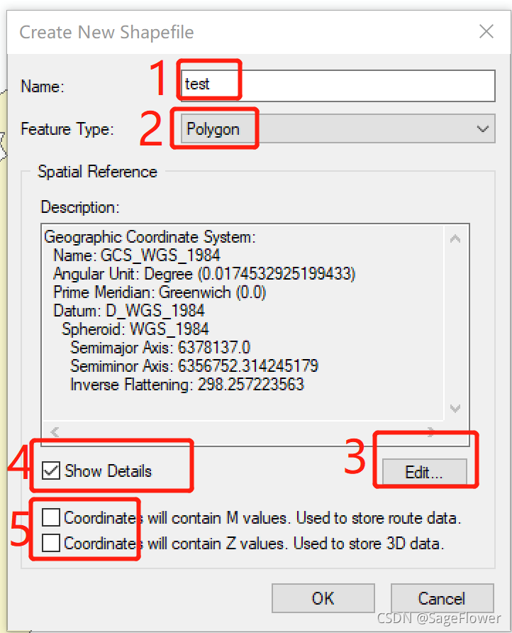
具体操作步骤见下面创建shp文件部分,
有一点要注意,就是:
红5那两个框不要勾选
大兴安岭VS大兴安岭地区
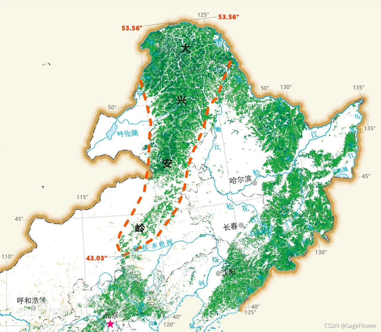
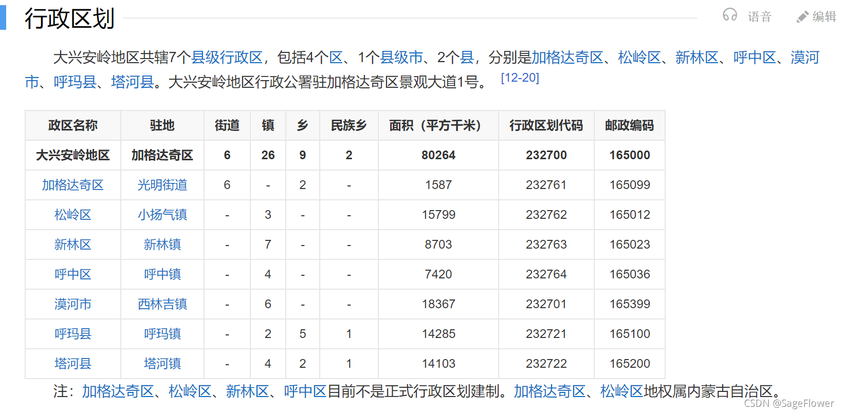
注意:大兴安岭和大兴安岭地区不是同一个概念
大兴安岭:https://baike.baidu.com/item/%E5%A4%A7%E5%85%B4%E5%AE%89%E5%B2%AD/563782?fr=aladdin
大兴安岭地区:https://baike.baidu.com/item/%E5%A4%A7%E5%85%B4%E5%AE%89%E5%B2%AD%E5%9C%B0%E5%8C%BA/2921262?fr=aladdin
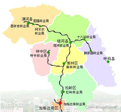
内蒙古大兴安岭林区:
https://baike.baidu.com/item/%E5%86%85%E8%92%99%E5%8F%A4%E5%A4%A7%E5%85%B4%E5%AE%89%E5%B2%AD%E6%9E%97%E5%8C%BA/18714959?fr=aladdin
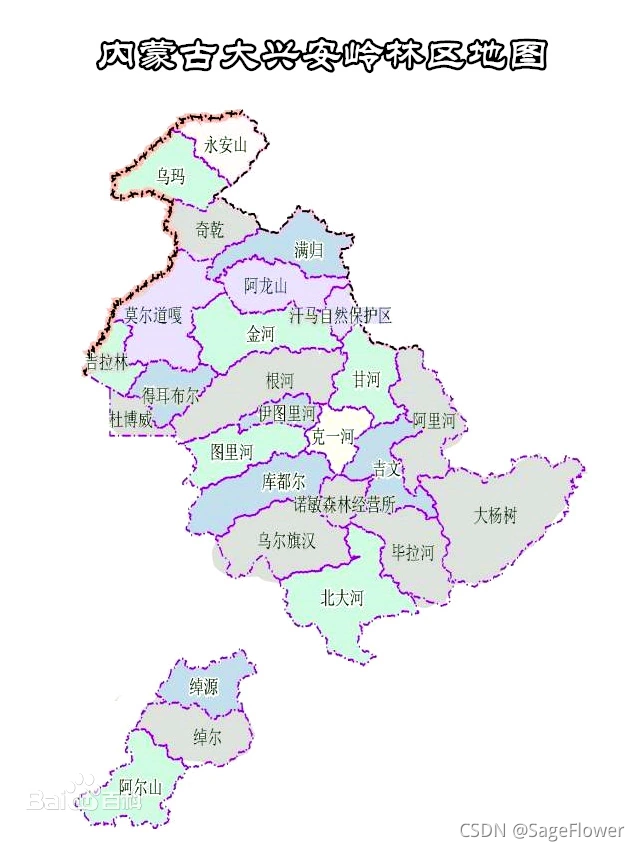
大兴安岭林区示意图:
黑龙江部分:
内蒙古大兴安岭林区地图
大兴安岭光学影像(google_earth地图)
链接:https://pan.baidu.com/s/1EhtFlQgrQulFq25D6gFMsw
提取码:p16r
arcgis如何创建dxalshapfile文件:
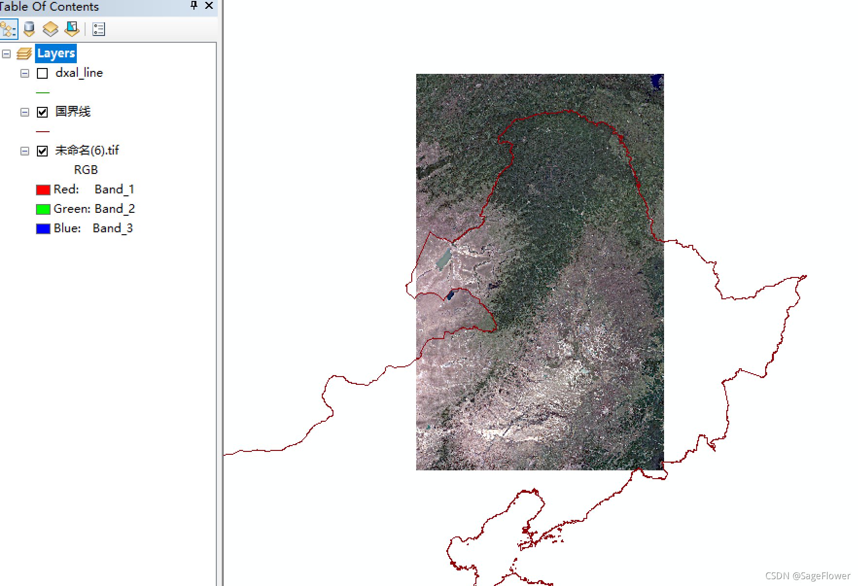
此shpfile仅用来大概指示大兴安岭山脉(林区)。
参考创建流程:
https://blog.csdn.net/liukunrs/article/details/81037571
(1)arcgis加载大兴安岭山脉google earth地图,国界线shp文件
(2)创建dxal林区shp文件
参考文章:https://blog.csdn.net/liukunrs/article/details/81037571
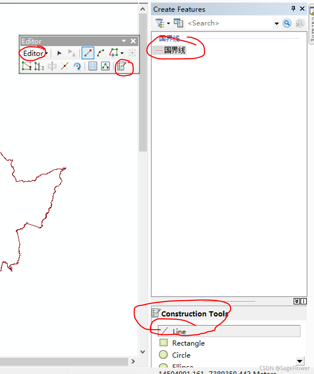
几点注意:
~1. 几个图层的坐标系要一致:经纬度坐标系?投影坐标系列?WGS84坐标系?
~2. 红1是开始编辑,保存编辑,结束编辑
红2是创建要素。
arcgis 怎么显示图层特征(多边形名称)
matlab
运算符且 或 等
https://www.cnblogs.com/shenxiaolin/p/6829180.html
matlab日期相减(相差几天)
https://blog.csdn.net/weixin_30356433/article/details/115983434
在线计算网页:http://bjtime.cn/riqi/
UTM坐标系的相关内容
https://blog.csdn.net/yyx20125084014/article/details/83116822
python一些技巧
python读取html文件中的表格table内容 https://www.cnblogs.com/wwwwwei/p/10728060.html
python中正则表达式findall https://zhuanlan.zhihu.com/p/139596371
python读取文件夹目录[https://www.cnblogs.com/yuanyongqiang/p/11714281.html](https://www.cnblogs.com
/yuanyongqiang/p/11714281.html)
