导语
本章根据百度地图API,实现仿钉钉打卡功能。用到了基础地图、覆盖物、定位图层、陀螺仪方法、悬浮信息弹框。
百度地图API地址 :Android 地图SDK
请先注册注册百度账号和获取密钥,并实现地图显示出来。(注意:密钥、权限要设置)
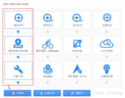
另外,我得说明本章所下载官方Demo 和 导入的jar包和so文件。自定义下载即可,如下图:
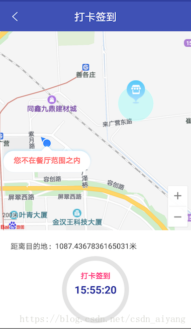
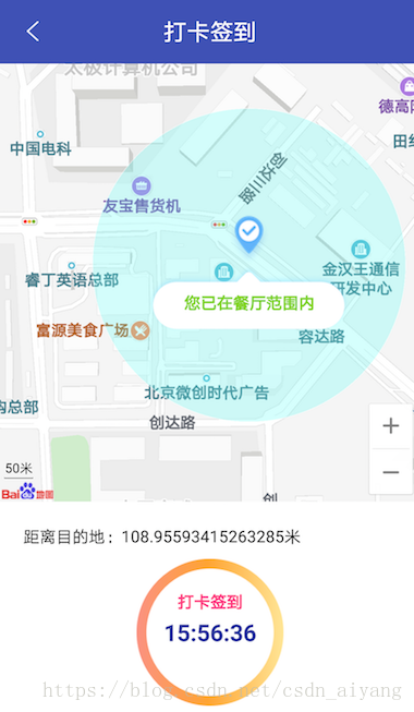
接下来,一起看实现效果。
源码Git地址:BaiduMapApp
效果图

实现代码·三步骤
第一步:基础地图和方向传感器
类先实现方向传感器 implements SensorEventListener
-
@Override
-
public void onSensorChanged(SensorEvent sensorEvent) {
-
double x = sensorEvent.values[SensorManager.DATA_X];
-
if (Math.abs(x - lastX) >
1.0) {
-
mCurrentDirection = (
int) x;
-
locData =
new MyLocationData.Builder()
-
// 此处设置开发者获取到的方向信息,顺时针0-360
-
.direction(mCurrentDirection).latitude(mCurrentLat)
-
.longitude(mCurrentLon).build();
-
mBaiduMap.setMyLocationData(locData);
-
}
-
lastX = x;
-
}
-
-
@Override
-
public void onAccuracyChanged(Sensor sensor, int i) {
-
-
}
-
/**
-
* 初始化地图
-
*/
-
private void initBaiduMap() {
-
mMapView = (MapView) findViewById(R.id.mapview);
-
mBaiduMap = mMapView.getMap();
-
mBaiduMap.setMapType(BaiduMap.MAP_TYPE_NORMAL);
-
mBaiduMap.setMyLocationEnabled(
true);
//开启定位图层
-
mSensorManager = (SensorManager) getSystemService(SENSOR_SERVICE);
//获取传感器管理服务
-
}
-
@Override
-
protected void onResume() {
-
super.onResume();
-
mMapView.onResume();
-
//为系统的方向传感器注册监听器
-
mSensorManager.registerListener(
this, mSensorManager.getDefaultSensor(Sensor.TYPE_ORIENTATION),
-
SensorManager.SENSOR_DELAY_UI);
-
}
-
@Override
-
protected void onPause() {
-
super.onPause();
-
mMapView.onPause();
-
}
-
-
@Override
-
protected void onStop() {
-
super.onStop();
-
//取消注册传感器监听
-
mSensorManager.unregisterListener(
this);
-
}
第二步:开启定位
-
/***
-
* 定位选项设置
-
* @return
-
*/
-
public void getLocationClientOption() {
-
mOption =
new LocationClientOption();
-
mOption.setLocationMode(LocationClientOption.LocationMode.Hight_Accuracy);
//可选,默认高精度,设置定位模式,高精度,低功耗,仅设备
-
mOption.setCoorType(
"bd09ll");
//可选,默认gcj02,设置返回的定位结果坐标系,如果配合百度地图使用,建议设置为bd09ll;
-
mOption.setScanSpan(
2000);
//可选,默认0,即仅定位一次,设置发起连续定位请求的间隔需要大于等于1000ms才是有效的
-
mOption.setIsNeedAddress(
true);
//可选,设置是否需要地址信息,默认不需要
-
mOption.setIsNeedLocationDescribe(
true);
//可选,设置是否需要地址描述
-
mOption.setNeedDeviceDirect(
true);
//可选,设置是否需要设备方向结果
-
mOption.setLocationNotify(
true);
//可选,默认false,设置是否当gps有效时按照1S1次频率输出GPS结果
-
mOption.setIgnoreKillProcess(
true);
//可选,默认true,定位SDK内部是一个SERVICE,并放到了独立进程,设置是否在stop的时候杀死这个进程,默认不杀死
-
mOption.setIsNeedLocationDescribe(
false);
//可选,默认false,设置是否需要位置语义化结果,可以在BDLocation.getLocationDescribe里得到,结果类似于“在北京天安门附近”
-
mOption.setIsNeedLocationPoiList(
false);
//可选,默认false,设置是否需要POI结果,可以在BDLocation.getPoiList里得到
-
mOption.SetIgnoreCacheException(
false);
//可选,默认false,设置是否收集CRASH信息,默认收集
-
mOption.setOpenGps(
true);
//可选,默认false,设置是否开启Gps定位
-
mOption.setIsNeedAltitude(
false);
//可选,默认false,设置定位时是否需要海拔信息,默认不需要,除基础定位版本都可用
-
client =
new LocationClient(
this);
-
client.setLocOption(mOption);
-
client.registerLocationListener(BDAblistener);
-
client.start();
-
}
-
/***
-
* 接收定位结果消息,并显示在地图上
-
*/
-
private BDAbstractLocationListener BDAblistener =
new BDAbstractLocationListener() {
-
@Override
-
public void onReceiveLocation(BDLocation location) {
-
//定位方向
-
mCurrentLat = location.getLatitude();
-
mCurrentLon = location.getLongitude();
-
//个人定位
-
locData =
new MyLocationData.Builder()
-
.direction(mCurrentDirection).latitude(location.getLatitude())
-
.longitude(location.getLongitude()).build();
-
mBaiduMap.setMyLocationData(locData);
-
mBaiduMap.setMyLocationConfiguration(
new MyLocationConfiguration(
-
MyLocationConfiguration.LocationMode.NORMAL,
true,
null));
-
//更改UI
-
Message message =
new Message();
-
message.obj = location;
-
mHandler.sendMessage(message);
-
}
-
};
第三步:更改UI
-
//设置打卡目标范围圈
-
private void setCircleOptions() {
-
if (mDestinationPoint ==
null)
return;
//打卡坐标不能为空
-
OverlayOptions ooCircle =
new CircleOptions().fillColor(
0x4057FFF8)
-
.center(mDestinationPoint).stroke(
new Stroke(
1,
0xB6FFFFFF)).radius(DISTANCE);
-
mBaiduMap.addOverlay(ooCircle);
-
}
-
/**
-
* 添加地图文字
-
*
-
* @param point
-
* @param str
-
* @param color 字体颜色
-
*/
-
private void setTextOption(LatLng point, String str, String color) {
-
//使用MakerInfoWindow
-
if (point ==
null)
return;
-
TextView view =
new TextView(getApplicationContext());
-
view.setBackgroundResource(R.mipmap.map_textbg);
-
view.setPadding(
0,
23,
0,
0);
-
view.setTypeface(Typeface.DEFAULT_BOLD);
-
view.setTextSize(
14);
-
view.setGravity(Gravity.CENTER);
-
view.setText(str);
-
view.setTextColor(Color.parseColor(color));
-
mInfoWindow =
new InfoWindow(view, point,
170);
-
mBaiduMap.showInfoWindow(mInfoWindow);
-
}
-
/**
-
* 设置marker覆盖物
-
*
-
* @param ll 坐标
-
* @param icon 图标
-
*/
-
private void setMarkerOptions(LatLng ll, int icon) {
-
if (ll ==
null)
return;
-
BitmapDescriptor bitmap = BitmapDescriptorFactory.fromResource(icon);
-
MarkerOptions ooD =
new MarkerOptions().position(ll).icon(bitmap);
-
mBaiduMap.addOverlay(ooD);
-
}
-
//改变地图缩放
-
private void setMapZoomScale(LatLng ll) {
-
if (mDestinationPoint ==
null) {
//打卡坐标不为空
-
mZoomScale = getZoomScale(ll);
-
mBaiduMap.animateMapStatus(MapStatusUpdateFactory.newLatLngZoom(ll, mZoomScale));
//缩放
-
}
else {
-
mZoomScale = getZoomScale(ll);
-
mBaiduMap.animateMapStatus(MapStatusUpdateFactory.newLatLngZoom(mCenterPos, mZoomScale));
//缩放
-
}
-
}
-
/**
-
* 获取地图的中心点和缩放比例
-
*
-
* @return float
-
*/
-
private float getZoomScale(LatLng LocationPoint) {
-
double maxLong;
//最大经度
-
double minLong;
//最小经度
-
double maxLat;
//最大纬度
-
double minLat;
//最小纬度
-
List<Double> longItems =
new ArrayList<Double>();
//经度集合
-
List<Double> latItems =
new ArrayList<Double>();
//纬度集合
-
-
if (
null != LocationPoint) {
-
longItems.add(LocationPoint.longitude);
-
latItems.add(LocationPoint.latitude);
-
}
-
if (
null != mDestinationPoint) {
-
longItems.add(mDestinationPoint.longitude);
-
latItems.add(mDestinationPoint.latitude);
-
}
-
-
maxLong = longItems.get(
0);
//最大经度
-
minLong = longItems.get(
0);
//最小经度
-
maxLat = latItems.get(
0);
//最大纬度
-
minLat = latItems.get(
0);
//最小纬度
-
-
for (
int i =
0; i < longItems.size(); i++) {
-
maxLong = Math.max(maxLong, longItems.get(i));
//获取集合中的最大经度
-
minLong = Math.min(minLong, longItems.get(i));
//获取集合中的最小经度
-
}
-
-
for (
int i =
0; i < latItems.size(); i++) {
-
maxLat = Math.max(maxLat, latItems.get(i));
//获取集合中的最大纬度
-
minLat = Math.min(minLat, latItems.get(i));
//获取集合中的最小纬度
-
}
-
double latCenter = (maxLat + minLat) /
2;
-
double longCenter = (maxLong + minLong) /
2;
-
int jl = (
int) getDistance(
new LatLng(maxLat, maxLong),
new LatLng(minLat, minLong));
//缩放比例参数
-
mCenterPos =
new LatLng(latCenter, longCenter);
//获取中心点经纬度
-
int zoomLevel[] = {
2500000,
2000000,
1000000,
500000,
200000,
100000,
-
50000,
25000,
20000,
10000,
5000,
2000,
1000,
500,
100,
50,
20,
0};
-
int i;
-
for (i =
0; i <
18; i++) {
-
if (zoomLevel[i] < jl) {
-
break;
-
}
-
}
-
float zoom = i +
4;
-
return zoom;
-
}
-
-
/**
-
* 缩放比例参数
-
*
-
* @param var0
-
* @param var1
-
* @return
-
*/
-
public double getDistance(LatLng var0, LatLng var1) {
-
if (var0 !=
null && var1 !=
null) {
-
Point var2 = CoordUtil.ll2point(var0);
-
Point var3 = CoordUtil.ll2point(var1);
-
return var2 !=
null && var3 !=
null ? CoordUtil.getDistance(var2, var3) : -
1.0D;
-
}
else {
-
return -
1.0D;
-
}
-
}
-
/**
-
* 处理连续定位的地图UI变化
-
*/
-
private Handler mHandler =
new Handler() {
-
@Override
-
public void handleMessage(Message msg) {
-
super.handleMessage(msg);
-
BDLocation location = (BDLocation) msg.obj;
-
LatLng LocationPoint =
new LatLng(location.getLatitude(), location.getLongitude());
-
//打卡范围
-
mDestinationPoint =
new LatLng(location.getLatitude() *
1.0001, location.getLongitude() *
1.0001);
//假设公司坐标
-
setCircleOptions();
-
//计算两点距离,单位:米
-
mDistance = DistanceUtil.getDistance(mDestinationPoint, LocationPoint);
-
if (mDistance <= DISTANCE) {
-
//显示文字
-
setTextOption(mDestinationPoint,
"您已在餐厅范围内",
"#7ED321");
-
//目的地图标
-
setMarkerOptions(mDestinationPoint, R.mipmap.arrive_icon);
-
//按钮颜色
-
//commit_bt.setBackgroundDrawable(getResources().getDrawable(R.mipmap.restaurant_btbg_yellow));
-
mBaiduMap.setMyLocationEnabled(
false);
-
}
else {
-
setTextOption(LocationPoint,
"您不在餐厅范围之内",
"#FF6C6C");
-
setMarkerOptions(mDestinationPoint, R.mipmap.restaurant_icon);
-
//commit_bt.setBackgroundDrawable(getResources().getDrawable(R.mipmap.restaurant_btbg_gray));
-
mBaiduMap.setMyLocationEnabled(
true);
-
}
-
// mDistance_tv.setText("距离目的地:" + mDistance + "米");
-
//缩放地图
-
setMapZoomScale(LocationPoint);
-
}
-
};
实现时间显示
-
/**
-
* 设置系统时间
-
*/
-
private Runnable run =
new Runnable() {
-
@Override
-
public void run() {
-
SimpleDateFormat simpleDateFormat =
new SimpleDateFormat(
"HH:mm:ss");
// HH:mm:ss
-
Date date =
new Date(System.currentTimeMillis());
//获取当前时间
-
mTime_tv.setText(simpleDateFormat.format(date));
//更新时间
-
mHandler.postDelayed(run,
1000);
-
}
-
};
mHandler.post(run);//设置系统时间
最后,收尾操作
-
@Override
-
protected void onDestroy() {
-
if (BDAblistener !=
null) {
-
client.unRegisterLocationListener(BDAblistener);
-
-
}
-
if (client !=
null && client.isStarted()) {
-
client.stop();
-
}
-
mMapView.onDestroy();
-
mMapView =
null;
-
mHandler.removeCallbacks(run);
-
super.onDestroy();
-
}
源码地址:https://github.com/aiyangtianci/BaiduMapApp
欢迎入坑。
(如果你觉得本人的文章对你有所帮助,客官慢走赏瓶水喝)


